Beautiful spring (or fountain) is one translation of “Belle Fontaine” from French. Locally, it was the name given to what we now call Frederick’s Springs, or Pheasant Branch Springs, in the Conservancy. These springs have enhanced human habitation in what is now Middleton for thousands of years.
New residential development centered on Belle Fontaine Boulevard will pose challenges to maintaining the quality and quantity of spring flow. Reduced infiltration of rainwater due to compacted soils and impervious surfaces, increased pumping of groundwater for new residents, and possible overflows of polluted stormwater are of concern.
Early European settlers were drawn to the area, already occupied by Ho-Chunk Indians, as an excellent stopping point on the U.S. Military Road between Green Bay and Prairie du Chien prior to Wisconsin statehood. A notable early settler in our area was Michel St. Cyr of French Canadian and Ho-Chunk parentage. He and other area traders lent French names to local lakes and landscape features, like Belle Fontaine. For more information, see Middleton Area Historical Society Newsletter, June 2015, no. 164.
Pheasant Branch Springs continue to be an important local resource, contributing over 1.5 million gallons per day of clear cool water to Lake Mendota, and supporting abundant plant and wildlife communities in the Conservancy. The Springs are an important place for education about the watershed, hydrology, human history, plants, and wildlife. The Springs area is one of the most popular destinations for visitors to the Conservancy in all seasons. Visit the pheasantbranch.org/listening-trail for more information.
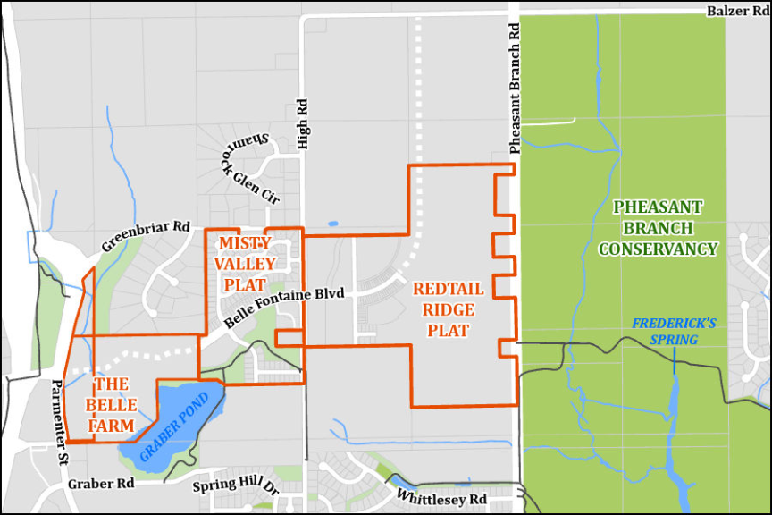
Belle Fontaine Boulevard is prominent on the City of Middleton Comprehensive Plan Road Network Map as a minor arterial roadway running between Hwy. Q and Parmenter Street. The boulevard will run on the same route as Balzer Road along the north boundary of the Conservancy. Starting at the Parmenter Street junction with Schneider Road, the new boulevard is currently being constructed to the east and will become the central route through the new Belle Farm residential and commercial neighborhood.
For more information see the Wisconsin State Journal article of 1/18/24 “This Middleton development will rely on geothermal, solar for energy” by Emilie Heidemann. The boulevard will connect to an existing section in the Misty Valley subdivision constructed ca. 2005, reaching High Road. A new section of the boulevard is being constructed east of High Road in the Redtail Ridge development, bending to the north to the current city boundary. See Friends Fall 2023 Newsletter, page 6, for more information about Redtail Ridge.
According to the City Comprehensive Plan map, it is envisioned that Belle Fontaine Blvd. will eventually be completed one-half mile north to join Balzer Road in what is now the Town of Springfield, directly west of the Conservancy. The area on either side of this road extension, totaling 140 acres, is listed as agricultural transition land, meaning it is possible that this will become another new residential settlement. All potential new developments are in the recharge area for the Pheasant Branch Springs.
The Friends are committed to monitoring these new developments and advocating for maximum application of Low Impact Development practices focused on stormwater runoff. The Watershed Committee will make every effort to work with local governments, property developers, and new residents to protect surface waters and groundwater in our area to sustain a vibrant Conservancy and our “Belle Fontaine” for the future.
Article written by Ken Wiesner, Board Member and Co-Chair, Watershed Committee