By Warren Gebert and Herb Garn
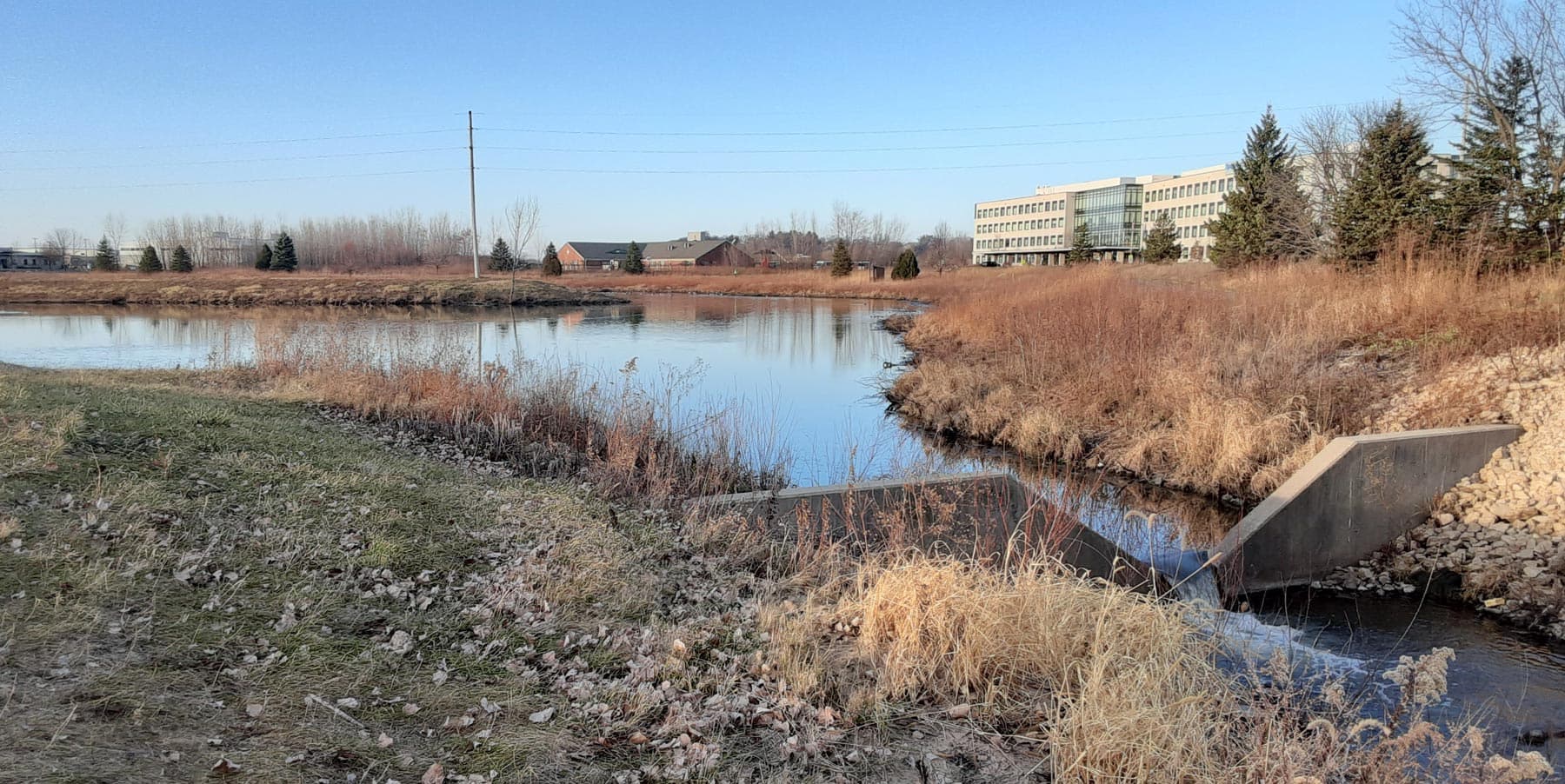
Photo: Herb Garn
In November last year, Middleton residents approved, by referendum, a large increase in the stormwater utility fee. The Friends of Pheasant Branch Conservancy, for the second time, strongly supported the City in its stormwater activities and campaigned to help pass this referendum. All these efforts were effective, and voters agreed, with the referendum being passed by with 67 percent of the vote. This showed that people in Middleton are concerned about protecting the water resources of Middleton and the Pheasant Branch Watershed.
At the May 21 meeting of the Middleton Water Resources Management Commission (MWRMC), speakers provided information and provisional—not yet USGS approved—stream monitoring data that illustrate the importance of the Stormwater Utility and increasing its funding through a quarterly stormwater utility fee.
Todd Stuntebeck from the USGS Upper Midwest Water Science Center discussed the preliminary results of its cooperative water monitoring program with Middleton that includes three streamflow and automated water quality monitoring stations. The station on Pheasant Branch at Parmenter Street has been operating for streamflow measurement since 1975 (celebrating its 50th year of operation!), for sediment data collection since 1978, and for total phosphorus (TP) data collection since 1993. Two other stations collecting data are the North Fork of Pheasant Branch at Airport Road and South Fork of Pheasant Branch at Highway 14, which have been in operation since 2012.
Mr. Stuntebeck stressed how unique it was to have this long record of streamflow, sediment, and phosphorus data. Middleton partially funds these stations along with other agencies to help plan and evaluate water resources management programs by Middleton, Dane County, and WDNR.
Mr. Stuntebeck also is the USGS project chief for monitoring the Yahara WINS Adaptive Management program being conducted by the Madison Metropolitan Sewerage District. That program, ongoing since 2012 in coordination with Dane County, the State of Wisconsin, UW-Madison, and local municipalities, is implementing land management practices to reduce the phosphorus going into Lake Mendota.
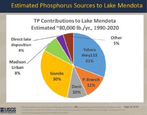
The illustration below shows that the average total phosphorus (TP) quantity entering Lake Mendota was about 80,000 pounds per year, and the average phosphorus contributed by Pheasant Branch was 12 percent of the total. The annual phosphorus load (quantity delivered per year) from Pheasant Branch since 2012 shows a decreasing trend despite the increase in streamflow during that period which would normally result in larger phosphorus loads.
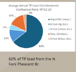
The USGS illustrations also showed that for the 2012-24 period, the North Fork produced 60 percent of the annual stream flow into the Confluence Pond (compared to 40 percent from the South Fork) and contributed 82 percent of the annual phosphorus and 74 percent of the suspended sediment. On average (2012-24), the Confluence Pond trapped about 55 percent (700 tons) of the annual suspended sediment and 30 percent (3,300 pounds) of the annual total phosphorus.
The presentation by Warren Gebert showed more results from the 2024 data collected at the three monitoring stations. The year 2024 was very wet, with 48.5 inches of precipitation, which is much greater than the long-term average (1991-2020) of about 37 inches per year. This large amount of rain resulted in several significant flooding events, with the largest occurring on the North Fork of Pheasant Branch. This storm was about a 20-year recurrence interval.
Two of Middleton’s major stormwater control structures are the South Pond (built in 1992, located just east of the Middleton Farmer’s Coop) on the South Fork and the Confluence Pond (built in 2002, located below the juncture of the North and South Forks). The flood peaks on the South Fork and main stem of Pheasant Branch below the Confluence Pond were much lower than those of the North Fork due to the flood reduction function of the ponds. The Confluence Pond is the City’s main structure for reducing flood peaks and trapping sediment and phosphorus that would otherwise be deposited in the Pheasant Branch Conservancy and Lake Mendota. In 2024, the Confluence Pond trapped 1,300 tons of sediment and 5,000 pounds of phosphorus. The North Fork, which is primarily agricultural land, contributed 82% of the sediment load and 72% of the phosphorus load to the Confluence Pond.
The monitoring results illustrate the value and benefits of the data collected and the significant progress Middleton has made in reducing flood peaks on Pheasant Branch and decreasing the sediment and phosphorus entering Pheasant Branch Conservancy and Lake Mendota. To maintain and enhance these reductions, it is necessary to remove the sediment containing phosphorus from these two ponds and many others. The Confluence Pond was dredged in 2016 and will require dredging again in the near future. The South Pond has never been dredged and will need to be dredged soon.
More improvement is needed to reduce phosphorus and sediment entering Lake Mendota and protect all water resources in light of increasing runoff from larger rains resulting from climate change and due to expanding urban development. Thanks to the increased revenue available for Middleton’s Stormwater Utility, and newly hired stormwater staff, the City is now better able to make progress on deferred maintenance projects and improve stormwater management. The increase in stormwater utility fees approved by voters last year and implemented by the City will make this work possible to maintain and improve Middleton’s storm water management program during times of increasing precipitation and runoff. The Friends remain committed to protecting and improving our natural spaces and maintaining healthy ecosystems for future generations to enjoy. Thank you for making this campaign a success story for the benefit of all Middleton residents!
Warren Gebert, was Chair of the Middleton Water Resources Management Commission for 49 years; Herb Garn is Co-chair of the Friends’ Watershed Committee.