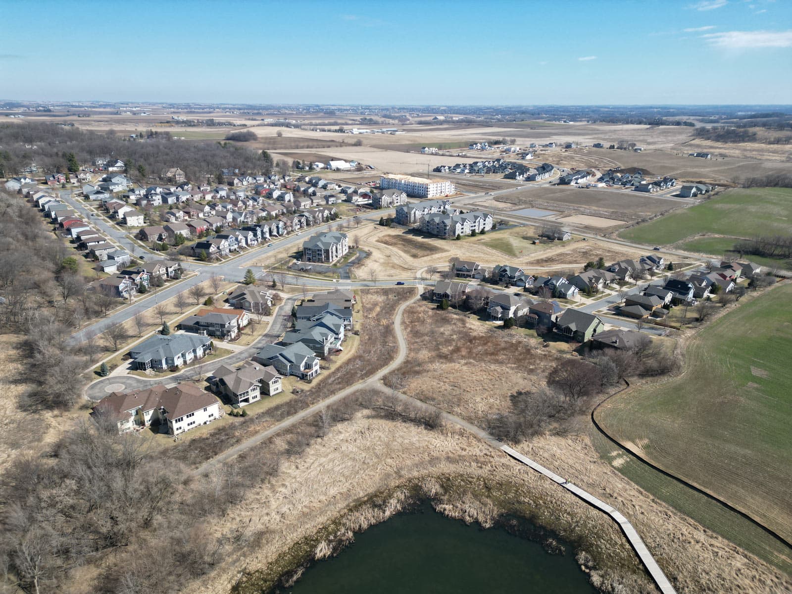
Aerial photo by Gary Sater. Northeast view from Graber Pond, showing path from Misty Valley stormwater facilities to High Road.
Article by Ken Wiesner, Friends of Pheasant Branch Conservancy, Watershed Committee
Graber Greenway is a name being used by the City of Middleton to describe a part of the northwest corner of the city. This area is adjacent to Pheasant Branch Conservancy and its wetlands. It runs westward from Pheasant Branch Road, crossing High Road to include the Graber Pond Conservancy. Importantly, this entire area is at a higher elevation (uphill) and drains stormwater and spring flows to Pheasant Branch Conservancy.
The area surrounding the Greenway is in transition, converting farm fields to residential subdivisions. Two subdivisions are currently being constructed; Redtail Ridge just west of the Conservancy, and Belle Farm north of Graber Pond (see past newsletters about these areas: Fall 2023 regarding Redtail Ridge and Winter/Spring 2024 about Belle Fontaine Boulevard).
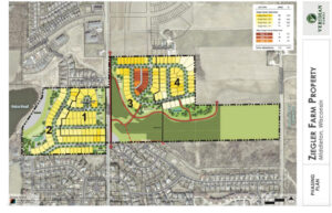
A third development is nearing construction (to be called Pheasant Crossing), stretching west from Pheasant Branch Road to the eastern shore of Graber Pond on the current Ziegler farm.
How this large area evolves is extremely important in many ways:
- Protection of water quality flowing into Pheasant Branch Conservancy, Pheasant Branch Creek, and down into Lake Mendota.
- Mitigation of invasive species that migrate downstream and downwind into Pheasant Branch Conservancy.
- Adding a recreation trail and other nature-based opportunities in an expanding part of the city, connected to Pheasant Branch Conservancy.
- Preserving a greenspace corridor for wildlife, restored with native plants.
- Welcoming many hundreds of new neighbors.
Graber Greenway is a feature of the City of Middleton Comprehensive Plan (see page 79 here), providing a network of natural conservancy lands amidst planned residential expansion
Want to know more about this important area? Let’s take a tour. Much of the tour route already exists, but some you will need to envision! Bring a compass.
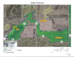
Point 1. On the west path in the Conservancy, next to Pheasant Branch Road and north of the Whittlesey Road trail crossing, is a bridge over a low area. You will find a small stream crossing here. At this point:
- Looking east into the Conservancy, you will find a fine sedge meadow that is being restored. Over the last six years, invasive shrubs have been cut and treated with herbicide to prevent resprouting invasive reed canary grass, hybrid cattails, and purple loosestrife have also been cut and treated, and the entire area has been subject to periodic prescribed burning funded in-part by DNR Lake and Stream grants. The success of this effort depends on the quality of the water it receives from the Graber Greenway.
- The stream itself runs to the east, joining Pheasant Branch Creek after running through wetlands. The stream elevation at this point is 859 feet (above Mean Sea Level). Lake Mendota and the Pheasant Branch Creek estuary are at an elevation of 850 feet.
- Looking west, you will find a large cattail marsh (left) and a tree line (right) in the lowland. The marsh sits below Pheasant Branch Ridge and receives spring flow, other groundwater discharge, and stormwater runoff from the residential developments uphill. The tree line is along an artificial drainage ditch on the Ziegler farm. Most of this ditch is dug several feet below the natural land surface in order to drain adjacent wetland for farming. The ditch runs about 3/8 of a mile straight west and can be a direct conveyance of nutrients and other pollutants to Pheasant Branch Marsh.
- Water flowing from a small marsh joins with the discharge from the ditch, crossing under Pheasant Branch Road in culverts. Water quality sampling is performed regularly at this point in a joint effort of Friends volunteers supported by Dane County.
Point 2. On the bike path running west from Pheasant Branch Road, just north and parallel to Whittlesey Road, is a bridge about halfway down the line of houses. At this point:
- You will see a spring pond discharging under the bridge to a small waterway leading to a marsh. This spring discharges year-round. The spring pond also receives direct discharges of stormwater from the residential area uphill.
- You are in the Pheasant Branch Ridge Greenway (Conservancy) area of the city. The Greenway at this point is a narrow band occupied by the bike path and, further west, a stormwater treatment pond, and a park/playground.
- Looking north about 200 yards you will see a tree line running east-west. That is the location of the drainage ditch on the Ziegler farm. Beyond that is a strip of active farmland. The sloping land further uphill will become part of the Redtail Ridge residential development.
- The 14-acre marshy area between the bike path and the drainage ditch is an abandoned outlot from the Pheasant Branch Ridge subdivision development. It is hoped that the city will acquire this land and attach it to the Pheasant Branch Ridge Greenway.
- Now, imagine this view in the not-too-distant future when the whole lowland area has been converted into a broad, high-quality wetland with a gently meandering stream course. Invasive trees and plants have been removed. The drainage ditch has been filled. These 40 acres will be effective at retaining stormwater pollutants and providing excellent wildlife habitat, protecting the adjacent Pheasant Branch Conservancy. Can this area become part of the Conservancy?
Point 3. The turnaround at the west end of Whittlesey Road. At this point:
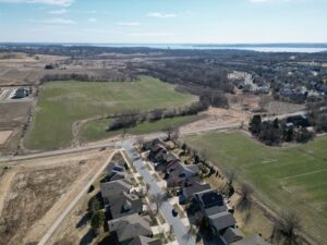
- Looking north and west, across the lowland area, imagine a new recreation trail connecting the Pheasant Branch Ridge Conservancy bike path with the existing trail in the Misty Valley subdivision (Point 4), avoiding a big hill to the south. The exact route for this connector has not been determined, but it is a feature of the Pheasant Crossing development plat (on the Ziegler farm property) under consideration by the city at this time. This “missing link” will provide an attractive route for bike and pedestrian traffic between Pheasant Branch Conservancy and Graber Road (Point 6), and bike/pedestrian routes to the west.
- Looking north, the current grassy hillside will soon become the Pheasant Crossing residential development. New houses in Redtail ridge are already visible. The Friends’ Watershed Committee is paying close attention to the stormwater management measures that will be needed to avoid nutrient and sediment discharges from the new residential areas. Comments on the plans have already been submitted to the city. We will remain closely involved as these developments are occurring and advocate for measures leading to the lowest possible impacts.
- The lowland area running down from High Road in the northwest view is a key component of Graber Greenway. This narrow and sloping area receives stormwater discharges escaping the Misty Valley and Redtail Ridge stormwater treatment systems, as well as downhill flow from a stormwater pond in an older subdivision to the west of High Road, south of Ziegler farm. The lowland area is currently degraded and is actively eroding toward the Ziegler drainage ditch, contributing sediment to the ditch. The city has identified this area for stabilization work.
- The lowland elevation at the High Road stormwater crossing near Caneel Trail is 892 feet. This is 33 feet higher than the stream elevation at Point 1 only half a mile east.
- High Road is planned for reconstruction running north to Belle Fontaine Boulevard. Careful design will be needed to avoid increasing, or concentrating, stormwater flows in this sensitive area.
Point 4. West of High Road, at Caneel Trail. At this point:
- An existing recreation trail skirts the Misty Valley stormwater treatment ponds and runs west toward Graber Pond.
- The treatment ponds and other stormwater management areas here are being added to the Graber Pond Conservancy in the current revision to the city Conservancy Lands Plan.
- The Misty Valley stormwater treatment ponds are in need of re-engineering as they are not performing as originally designed.
- Neighbors are restoring native plants at Caneel Corner. This project was recognized with a 2024 City Sustainability Award.
Point 5. Welcome to Graber Pond! At this point:
- You are on the city recreation trail in the Graber Pond Conservancy.
- Graber Pond is the largest of the city’s five glacial kettle ponds. The pond is normally land-locked and varies in size and depth depending on groundwater and precipitation levels. Pond surface elevations vary from 900 to 904 feet MSL (Mean Sea Level). This is roughly 50 feet above Lake Mendota’s level. The pond overflows just above elevation 905.
- A large earth mound at this point may be of archaeological significance.
- The area north of the pond and running west to Parmenter Street is becoming the Belle Farm residential development along Belle Fontaine Boulevard.
- The farm field to the southeast will become part of the Pheasant Crossing residential development. A significant buffer area near Graber Pond should be preserved as conservancy land.
- The recreation trail running south to the overlook (Point 6) is likely to be relocated to the east onto higher ground in the subdivision development.
- The wetland areas surrounding Graber Pond provide a good breeding habitat for birds and amphibians. The pond is regularly visited by migrating waterfowl.
Point 6. Graber Pond Overlook. At this point:
- This is a nice view of the pond setting and watershed in the glacial valley. The wooded hill across the pond is an existing low-density residential subdivision. How will this view change with the completion of the Belle Farm development?
- You have traveled about 1.4 miles from Point 1 on this route.
- The south boundary of Graber Pond Conservancy and the city recreation bike/pedestrian path is at Graber Road. It is possible (but not easy) to connect to the Hwy. 12 bike path and the city trail system by crossing Parmenter Avenue.
- It may be possible to complete a recreation trail loop around Graber Pond. There will certainly be increased demand for outdoor recreation as more neighbors move into the new subdivisions.
- A revision to the Graber Pond Conservancy Master Plan is expected in 2025. Middleton District 6 Alder Lisa Janairo has expressed interest in holding public meetings to assist in Plan development. Is a “Friends of Graber Pond” on the horizon?
The Friends of Pheasant Branch Conservancy are actively engaged in wide-ranging work in the Graber Greenway area. One of the most helpful recent developments is the proposal of a specific list of action items commissioned by the City Public Works Department, titled Graber Greenway Improvements Project. (See the proposal here.) The proposal was created by MSA Engineering working with city engineers and was received in November 2024. This proposal is in the process of being approved by the city. Funding needs to be arranged.
The Friends’ Board is on record as “wholeheartedly endorsing a Graber Pond greenway connection to Pheasant Branch Conservancy” and “offering our unwavering support.” “The potential of this project aligns perfectly with the Friends’ mission to restore, protect and promote the Pheasant Branch Conservancy and its watershed. The creation of a continuous corridor between Graber Pond and the Conservancy will not only benefit wildlife but also improve water quality throughout the Yahara chain of lakes.” (comments of Hans Hilbert, FOPBC co-president, on 5/1/24 to Middleton Mayor Emily Kuhn).
There is not space in this article to explore the many initiatives included in the Graber Greenway Improvements Project proposal. Be assured that future articles from the Friends Watershed Committee and Restoration and Management Committee, will keep you informed of progress.
One of the most exciting and beneficial projects from the Friends’ perspective will be restoring the roughly 40 acres of wetlands immediately adjacent to the Conservancy west of Pheasant Branch Road. This will include filling the existing drainage ditch on the Ziegler farm, allowing a natural watercourse to form and arresting the current channel erosion on the west end of this area near High Road.
This restored wetland area will require the utmost protection from impacts due to stormwater from the adjacent new residential developments and from outflow from the Graber Pond watershed. Friends workgroups will continue to be actively focused and engaged in protection and advocacy work. For instance, we have recently submitted detailed comments on the stormwater management aspects of the proposed Pheasant Crossing development on the Ziegler farm.
We are also engaged in revisions to the City Conservancy Lands Plan and the Graber Pond Master Plan. There are very many planning, zoning, and engineering details that affect the evolving Graber Greenway area. The Friends look forward to being a positive force and partner in this evolution.