Land Use History and Hydrology
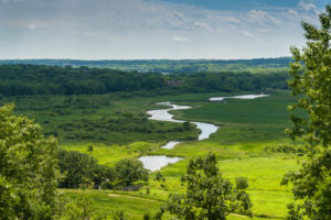
The Pheasant Branch Watershed covers a 24-square-mile area within the northwest portion of the Yahara River Watershed. It includes parts of the towns of Springfield and Middleton and the cities of Middleton and Madison. Land use is roughly 50/50 urban and rural. The North and South forks of Pheasant Branch Creek meet just west of USH 12 in Middleton and the flow about 2 ½ miles to Lake Mendota. The North Fork in the Town of Springfield is mostly rural and the South Fork in the Town of Middleton and the cities of Middleton and Madison is mostly urban.
Prior to settlement, much of the rainfall in the watershed drained into a large wetland in the area of current day Middleton Airport (Morey Field). Early settlers drained the wetland and channelized Pheasant Branch Creek (creating the North Fork) in the 1850s in order to harvest peat and farm the old glacial lake bed. These changes and subsequent development greatly expanded the drainage network, increased runoff, destabilized the channel, increased erosion, and deteriorated water quality. Consequently, the ability of this area to stabilize downstream flows, protect water quality and recharge groundwater has been diminished.
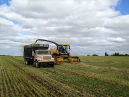
 Land use in the northern part of the Pheasant Branch Creek Watershed is mostly agricultural with the result that nutrient-laden runoff flows from the watershed and into Lake Mendota. This runoff contains significant amounts of sediment and phosphorus, which pollute the Pheasant Branch Creek and contribute to the algae blooms that plague Lake Mendota. Runoff from the urban areas in the South Fork also contribute large amounts of sediment, phosphorus and other pollutants which end up in the Conservancy and Lake Mendota. In fact, Pheasant Branch Creek is one of the major tributaries that deliver phosphorus to Lake Mendota.
Steps are being taken to correct this situation. Pheasant Branch Creek Watershed is part of an innovative, multi-faceted approach known as “adaptive management” to reduce phosphorus. Led by Yahara WINS (Yahara Watershed Improvement Network,) this pioneering approach brings together diverse partners - farmers, businesses, cities, towns, Madison Metro Sewerage District, and the county - to fund and carry out a range of conservation practices including cover crops, strip cropping, manure injection, streambank buffers, biofilters, and grassy swales to control and reduce the amount of phosphorus flowing through the watershed and entering the Conservancy and the Yahara Lakes. The Friends of Pheasant Branch strongly support the adaptive management effort.
CRITICAL ISSUES FOR THE PHEASANT BRANCH WATERSHED
The main threats to the quantity and quality of water in the Pheasant Branch Creek Watershed are agricultural runoff and urban development.
1. Stormwater Management – Managing large storm runoff in the upper reaches of the watershed is critical for protecting Pheasant Branch Creek downstream from the Confluence Pond where the North and South forks of Pheasant Branch Creek meet. The extreme rain event of August 20 – 21, 2018 demonstrated the physical and biological destruction that can occur in the creek corridor below the Confluence Pond under extremely high flow conditions. The City of Middleton’s Water Resources Management Commission has identified key flood control management locations in the North Fork of Pheasant Branch Creek and continues to analyze optimal management options in both the North and South forks of Pheasant Branch Creek. The Friends support efforts to acquire and protect these areas.
2. Phosphorus Reduction - Pheasant Branch Creek is a large contributor of algal-producing phosphorus to Lake Mendota and the Yahara Chain of Lakes. The watershed is part of an “adaptive management” approach to reduce phosphorus via a diverse partnership, Yahara WINS (farmers, businesses, cities, towns, county, etc.) and innovative techniques to reduce the amount of phosphorus flowing through the watershed and into the lakes. In urban areas Dane County’s “Leaf Free Streets Campaign” is also an effective program that the Friends champion to reduce phosphorus loadings through homeowners removing street leaves before rain events.
3. Salt Reduction - the Pheasant Branch Watershed has seen a steady increase in salt pollution over the past few decades due to deicing salt (sodium chloride) that washes off hard surfaces and into Pheasant Branch Creek and Lake Mendota. Years of salt applications threaten drinking water, aquatic and terrestrial life, and cause damage to infrastructure and vehicles. The Friends and other partners use the “Salt Wise Program” to educate the public and salt vendors about wise salt use.
4. Developing a shared vision and Coordinated Decision-Making - The Pheasant Branch Creek Watershed covers parts of 4 governmental units - the cities of Middleton and Madison and the towns of Springfield and Middleton. The City of Middleton, Dane County and the Department of Natural Resources all own land in the Pheasant Branch Conservancy. The Friends are the only group dedicated to advocating for the watershed as a whole and we encourage these entities to work together to plan and implement the best management practices for the watershed.

