By Rick Eilertson, Friends of Pheasant Branch Conservancy Board Member and Watershed Committee Member
The Yahara Watershed is a vital ecological landscape that encompasses the Yahara River, a 62-mile tributary of the Rock River that includes the lakes that surround Madison: Lake Mendota, Monona, Waubesa, and Kegonsa. Ultimately, it joins with the Rock River north of Janesville, becoming part of the Mississippi watershed.
Two pollutants, sediment and phosphorus, have conspired to threaten the water quality of this watershed, prompting the DNR to place the Pheasant Branch Creek on the Impaired Waters List.
Sediment enters the watershed through runoff from agricultural lands, urban development, and eroding streambanks, clouding the water and impacting fish spawning grounds and the growth of aquatic plants.
Phosphorus is an essential element for life on this planet. It is an important nutrient for plant growth, vital to the integrity of bones and teeth, a key ingredient in our body’s ability to produce energy, and part of the DNA double helix. Dan Egan’s book, “The Devil’s Element”, documents the discovery of phosphorus and its role as the elemental link in the life cycle of animals, plants, and humans. Egan describes this “cycle of life” as having been transformed into a straight line trending in opposing directions: an oversupply in our waterways, resulting in toxic algae blooms that threaten our well-being, and a scarcity of phosphorus due to limited earth-bound reserves.
To reconstitute the “cycle of life,” we need to find an ecological balance between our overuse and the depletion of reserves. On the overuse side of the equation, our community has focused on finding the right amount of phosphorus.
Pheasant Branch Creek Monitoring
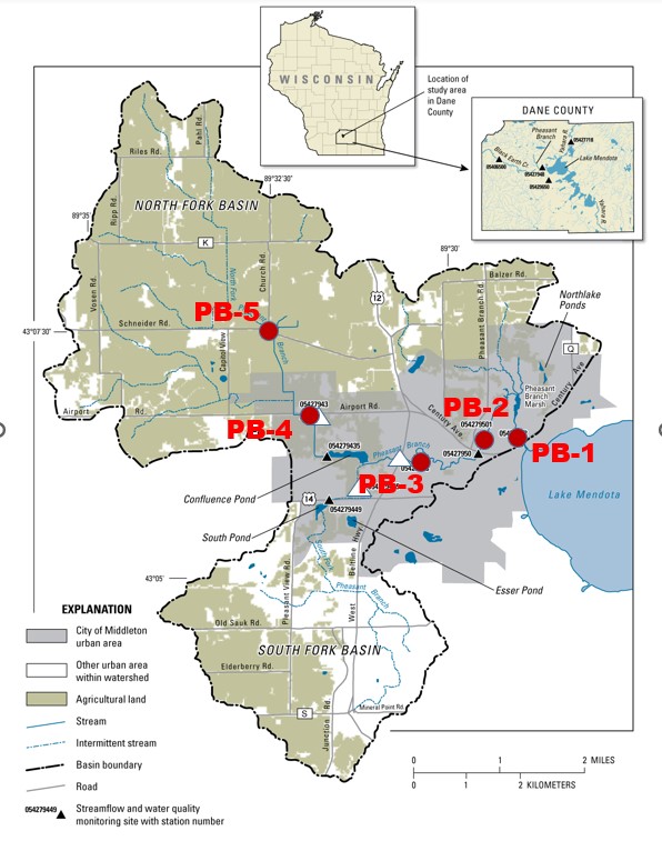
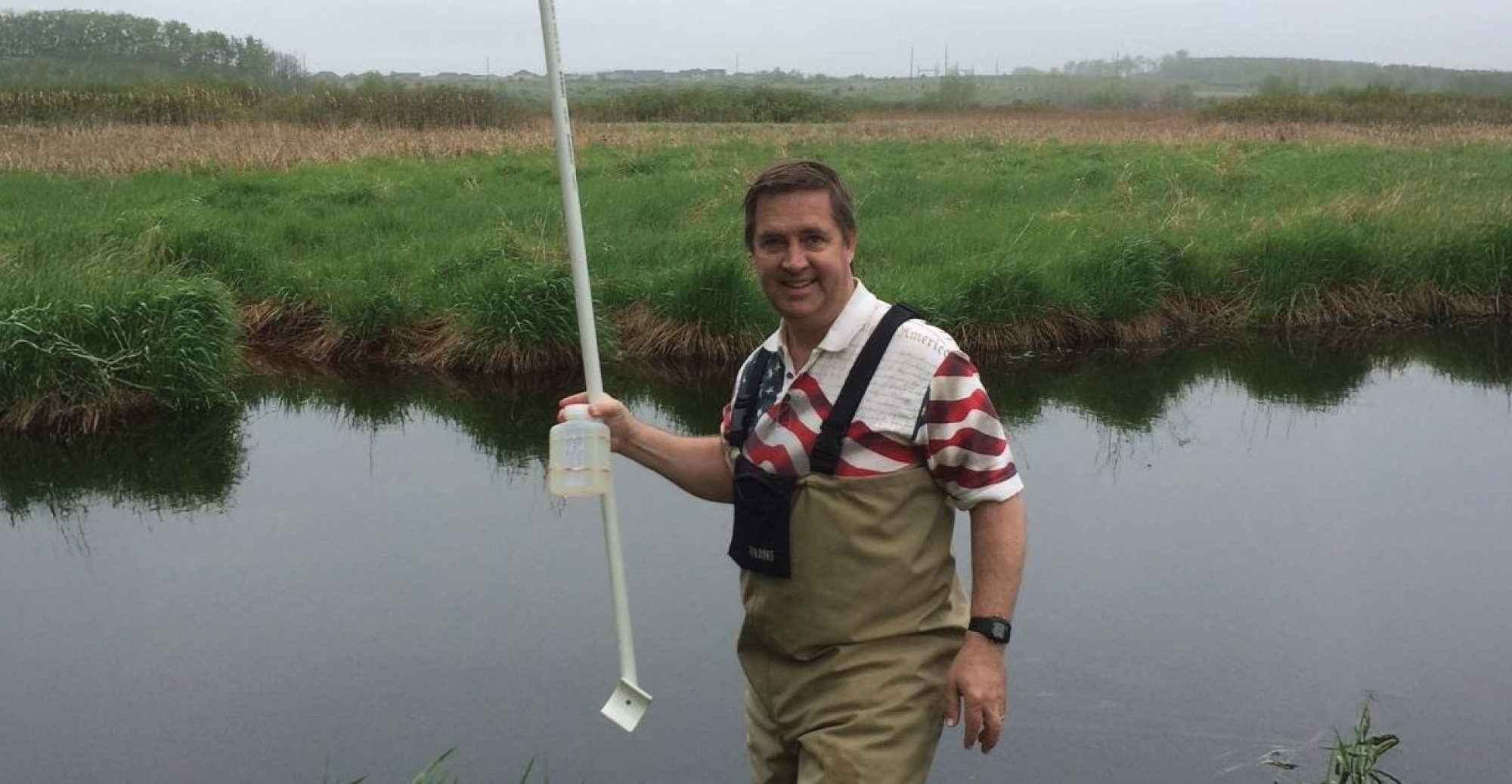
There are many good things that the Friends and our partners are doing to help address this environmental threat. Members of the Friends Watershed Committee have been serving as stream volunteers at five different sites along Pheasant Branch Creek for over a decade. (See Figure A.)
Volunteer coordination has been facilitated by the Rock River Coalition in conjunction with the Yahara Watershed Improvement Network (Yahara WINS) Adaptive Management Program. This monitoring follows the Water Action Volunteer (WAV) monitoring protocols to gather monthly air temperature, water temperature, dissolved oxygen, water transparency, and water samples. The samples are taken to Madison Metropolitan Sewerage District’s (MMSD) laboratory. MMSD analyzes these water samples for Total Suspended Solids (TSS), 3 versions of nitrogen (NO3+NO2, TKN, and NH3-N) and two versions of phosphorus (TP and PO4).
Site PB-1 is the closest to Lake Mendota and Site PB-5 is the furthest away. I started sampling at site PB-5 in 2021 and am now assisting with PB-4, PB-2, and PB-1 along with other volunteers. I started doing monthly winter monitoring in 2022 and the plan is to continue this for all four sites.
Pheasant Branch Conservancy Water Quality Monitoring
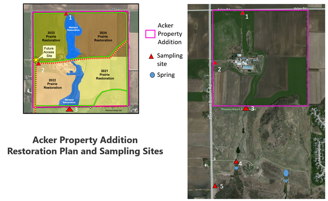
In addition to the creek monitoring, stream monitoring within the Conservancy has been led by Herb Garn, Friends Watershed Committee Chair, and a team of volunteers. Since fall 2019, following Dane County’s acquisition of the Acker dairy farm on the north boundary of Pheasant Branch Conservancy, four sites have been monitored. Articles on this monitoring have been chronicled in the Friends’ Fall 2019 and Winter 2019-20 newsletters. The Spring 2023 newsletter highlights the expansion of sampling efforts to add a fifth sampling point at Pheasant Branch Road to analyze runoff coming from the Western Tributary (now referred to as Graber Greenway). This sampling point is downstream from several recent new residential developments in the City of Middleton (Belle Farm, Red Tail Ridge, and Pheasant Crossing). (See Figure B.)
This monitoring effort has been coordinated with the Dane County Land and Water Resources Department, and the samples are taken to the Wisconsin State Lab of Hygiene (SLOH). The SLOH analyzes these water samples similar to that of the MMSD lab, providing congruent data that includes Total Suspended Solids (TSS), two versions of nitrogen (NO3+NO2 and TKN), and two versions of phosphorus (TP and PO4).
Water Quality Data Entry and Access
The water quality data for both monitoring efforts is entered into the Wisconsin Department of Natural Resources (WDNR) monitoring database. This data is used to inform conservation efforts on streams, creeks, rivers, and lakes throughout Wisconsin. Every two years, WDNR makes determinations on whether to add segments to or remove them from the Environmental Protection Agency’s (EPA’s) 303(d) Impaired Waters List based on levels of the specific pollutants of concern tagged with each stream or lake segment. This data is accessible to the public via WDNR’s Surface Water Data Viewer.
Interestingly, after the conversion of the Acker Property Addition to prairie vegetation, there have been several times that there’s literally no flow to be able to gather stream data. This aligns with Dane County’s expectations: that perennial prairie vegetation would reduce runoff rates and volumes. The volunteer monitoring data will be a key to showing the extent of improvement in reducing sediment (TSS) and phosphorus (TP) loading downstream to Pheasant Branch Creek. We hope to share a report from Dane County on the results of six years of sampling in upcoming Friends e-newsletters.
Conservation Work by Partners in the Watershed
Numerous partners have been working on conservation improvements in the Pheasant Branch Creek watershed. Below is a brief summary of the scope of each organization, which includes an impressive range of diverse stakeholders.
- The Clean Lakes Alliance (CLA) is a nonprofit organization devoted to improving the water quality of the lakes, streams, and wetlands of the Yahara River Watershed. The CLA is a unique partnership of diverse stakeholders working together to raise community awareness of the issues facing the watershed, advocate for the welfare of our lakes, and help secure the funding needed to clean and protect these waterways. The CLA works closely with state, county and local government agencies, waterway user groups, lakefront property owners, and community nonprofits to serve as both a positive voice for the promotion of our cherished lakes and a fundraising vehicle for achieving these ends.
- Yahara Pride Farms (YPF) is the agricultural affiliate organization of the Clean Lakes Alliance. Farmers in the program work on innovative ways to manage phosphorus and other nutrients on their farms, while improving soil and water quality through agricultural conservation practices and technologies. YPF is testing the business case for several innovative conservation practices by demonstrating pilot projects and showcasing the phosphorus and nitrogen savings, soil quality benefits, and the increase in profitability for farmers’ operations.
- The Dane County Land and Water Resources Department has numerous experts on staff working in both rural agricultural areas and the urban municipal boundaries of the Pheasant Branch Creek watershed. The Department’s Land Conservation Division works to protect and improve local land and water resources while providing benefits to both the environment and agricultural operations. The division manages several voluntary conservation-related projects and programs, which include the planning, design, and implementation of agricultural conservation practices to reduce soil erosion and protect water quality.
- The Madison Area Municipal Stormwater Partnership (MAMSWaP) is a group of 22 municipal governments. The primary municipalities doing good work in the Pheasant Branch Creek watershed are the City of Middleton, the City of Madison, the Town of Middleton, the Town of Westport, and Dane County. Everyone meets quarterly to learn from best practices achieved through their programming. I’ve been volunteering as a member of the Information and Education Committee since 2002 and have enjoyed the opportunity to learn what works and what doesn’t in influencing human behavior regarding water quality and quantity.
What is the Right Amount of Phosphorus?
So, you’ve almost reached the end of this article, and you’re probably wondering, “Rick, what is the ‘right amount’ of phosphorus?” My answer: It depends. WDNR water quality experts have set specific concentrations of total phosphorus (TP) for different types of water bodies. For example, in various sections of the Rock River, including Pheasant Branch Creek, the WDNR has identified 0.075 milligrams per liter (mg/L) as the recommended target for TP. (See the Rock River Total Maximum Daily Load report). Our next step will be to explore this further and determine how close Pheasant Branch Creek is to that target.
What Are Some Other Next Steps?
The Clean Lakes Alliance recently created the “Renew the Blue Council,” which includes 24 organizations so far and is poised to continue growing. The Friends of Pheasant Branch Conservancy has two delegates to the council: Tim Hansel (Friends Education Coordinator) and me. We’ll be attending the kickoff meeting on February 4 and four follow-up meetings in 2026.
On the agenda will be an annual community event, Imagine a Day Without Water. For over 10 years, this event has brought together a diverse group of stakeholders–business leaders, community advocates, educators, and concerned citizens– to highlight our need for clean water, inspiring us all to play a role in protecting our vital water resources.
In the meantime, reach out if you have any questions, comments, and suggestions about our efforts to improve water quality. Your ideas, concerns, and questions are valuable and necessary as we search for how we can impact the ecological balance.