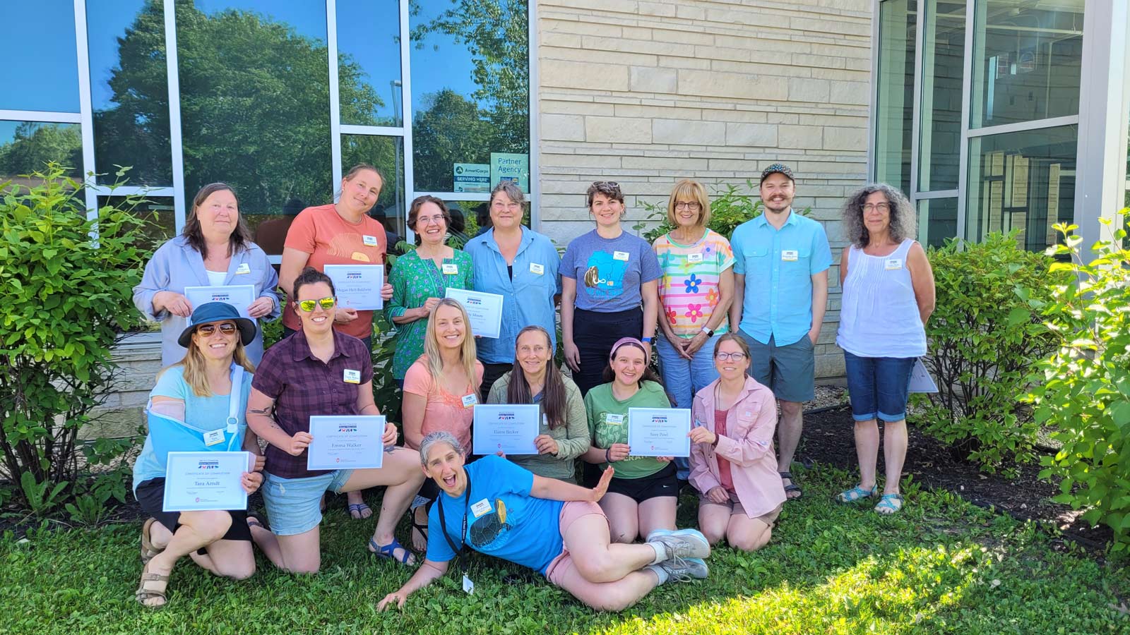
By Colleen Robinson, Friends of Pheasant Branch Master Naturalist Course Coordinator The Friends of Pheasant Branch Conservancy have hosted their highly sought-after Wisconsin Master Naturalist Program course for eight years. Since the beginning, this partnership has been good for participants, for Conservancy land, and for the Friends, and each year it gets even better! The Program is administered through University of Wisconsin Extension, in partnership with organizations across the state, to provide 40 hours of instruction to participants who want to become “Wisconsin Master Naturalists” and volunteer 40 hours per year or more to help Wisconsin’s natural landscapes. Focusing on three key contribution categories—citizen science, land management/restoration, and education—graduates of the Friends’ course over the years have enhanced the Conservancy tremendously. Here’s just a tiny snapshot: At least eight graduates have joined and served terms on the Friends Board of Directors More than 20 graduates have created or helped lead school field trips in the Conservancy Still more have volunteered for Friends events such as Conservancy Days, Make a Memory Day, the Prairie Chase Run, and more The Friends’ e-bird monitoring program started with a graduate, and more recent graduates are joining the team to keep up the effort of tracking how prairie restorations and other land management are serving birds at the Conservancy Others arranged for slip-reducing strips to be added to shaded boardwalks, created a self-guided walking tour of Conservancy highlights, and so much more! Thank you to our partners at UW Extension, to all our guest speakers, tour guides, and teaching team, whose contributions make our course one of the best out there, and to all our eager participants who continue to do great, creative work in service to Wisconsin’s natural treasures.
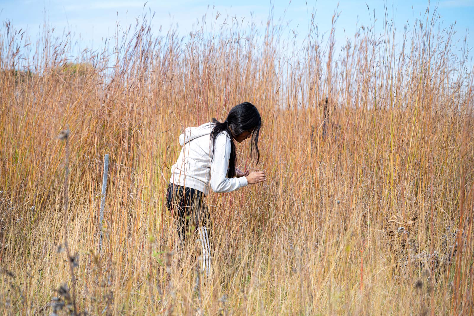
By Tim Hansel (Friends of Pheasant Branch Conservancy Education Coordinator), and Deb Weitzel & Janice Kehler (FOPBC Board Members) Bringing Science to Life at the Conservancy The Friends of Pheasant Branch Conservancy have always believed in the power of community partnerships to foster environmental stewardship and education. One of our most cherished collaborations is with the Middleton-Cross Plains Area School District, where we work closely with students and teachers to promote curriculum-aligned field trips that bring classroom topics to life in the Conservancy. This partnership includes programs that span all grade levels, enhancing our students’ understanding of environmental science and contributing to the health and vitality of local ecosystems. Teaching and Maintaining Rain Gardens with 6th Graders Several years ago, after the renovation of Kromrey Middle School, rain gardens were excavated and planted. However, due to a lack of maintenance, these gardens quickly fell into disarray. This presented an opportunity for the Friends of Pheasant Branch Conservancy to step in and collaborate with the 6th graders and their science teachers to revitalize and maintain these important ecological spaces. Each fall and spring, naturalists from the Friends visit the school to work with the students and help them understand the importance of rain gardens. During these visits, students learn about how rain gardens manage stormwater runoff, reducing the risk of flooding and filtering pollutants from rainwater, which improves the quality of water entering local streams and rivers. They also discover how these gardens provide crucial habitat for local wildlife, from insects and birds to small mammals. The students don’t just learn about rain gardens—they take an active role in maintaining them. Working together, they remove invasive species that threaten the health of the gardens, plant native prairie species like spiderwort, stiff-goldenrod, and cup plant, and monitor the overall condition of the gardens. Through this hands-on experience, the students develop a deeper appreciation for environmental stewardship and gain practical knowledge about ecology and conservation. The impact of this project extends beyond the students themselves. By revitalizing the rain gardens, they contribute to better water management, improved water quality, and enhanced biodiversity in the area. Our partnership also strengthens the bond between the community and the natural world, instilling a shared sense of responsibility for the health of our environment. Annual 8th Grade Hydrology Field Trip In 2022, Maria Pittner, an 8th grade science teacher at Kromrey Middle School, took the Wisconsin Master Naturalist training offered by the Friends of Pheasant Branch Conservancy. As part of her training, she developed a project that would bring the 8th graders to the Conservancy each fall for an immersive learning experience in hydrology and conservation. Since then, this field trip has become an annual tradition, eagerly anticipated by students and teachers alike. Over the course of two days, approximately 300 students participate in a variety of activities designed to deepen their understanding of water science and environmental preservation. They collect seeds from native prairie plants, playing an active role in the restoration efforts of the Conservancy. They hike to the top of Frederick’s Hill, where they can take in a breathtaking view of the Conservancy while learning about the local geography and ecosystems. They dig into the earth to explore different soil types and discuss the importance of springs in the hydrological cycle. Through an interactive activity on water use, they gain insight into the ways they can conserve this precious resource in their daily lives. Perhaps most memorably, they conduct experiments to measure how water infiltrates different soil types, helping them grasp the critical role of soil health in water management. To ensure a comprehensive learning experience, the field trip is organized into five different stations, each led by naturalists from the Friends group and members of the watershed and restoration committees. Each station introduces students to a different aspect of hydrology and conservation, giving them a well-rounded and engaging educational experience. The field trip is not just informative—it is a source of excitement and discovery for the students. As they move from one station to the next, their enthusiasm is evident in their questions, observations, and lively discussions. Even amidst the occasional bursts of youthful exuberance, their curiosity and eagerness to learn shine through. For many of them, this field trip is a defining moment that deepens their connection to the natural world and sparks a lifelong interest in environmental conservation. Service Projects: Freshmen Help Restore Local Prairies Freshmen biology students numbering about 600, will leave the classrooms behind and engage in conservation work at several natural areas around the community. For many of them, this experience built on what they had learned in earlier years—especially those who had explored rain gardens and native plants as students at Kromrey Middle School. Students are sent to several sites—including the Dane County and City of Middleton units of Pheasant Branch Conservancy, Holy Wisdom Monastery, and Governor Nelson State Park—where they spent their 90-minute biology class actively caring for the land. Some groups collect valuable prairie seeds that are essential for restoring and enhancing native prairie habitats both at the monastery and in county parks. Other students tackle invasive species like buckthorn and honeysuckle, helping to protect native plant communities by removing aggressive woody shrubs that would otherwise dominate. The effort is a powerful example of how service learning and environmental education can come together. “Many hands make light work,” as the saying goes. Kevin Short and Tony Krohm from the City of Middleton Parks Department remarked on the visible impact students had. In just one class period, a group of 125 students cleared a significant amount of invasive brush—work that would have taken staff days to accomplish. This partnership between school and local conservation organizations has been ongoing for years. Its lasting impact is perhaps best summed up by a former student who, when asked what they remembered most from freshman biology, replied: “Going to the Conservancy and collecting seed.” That one hour in nature left a deeper impression than anything else in the yearlong …
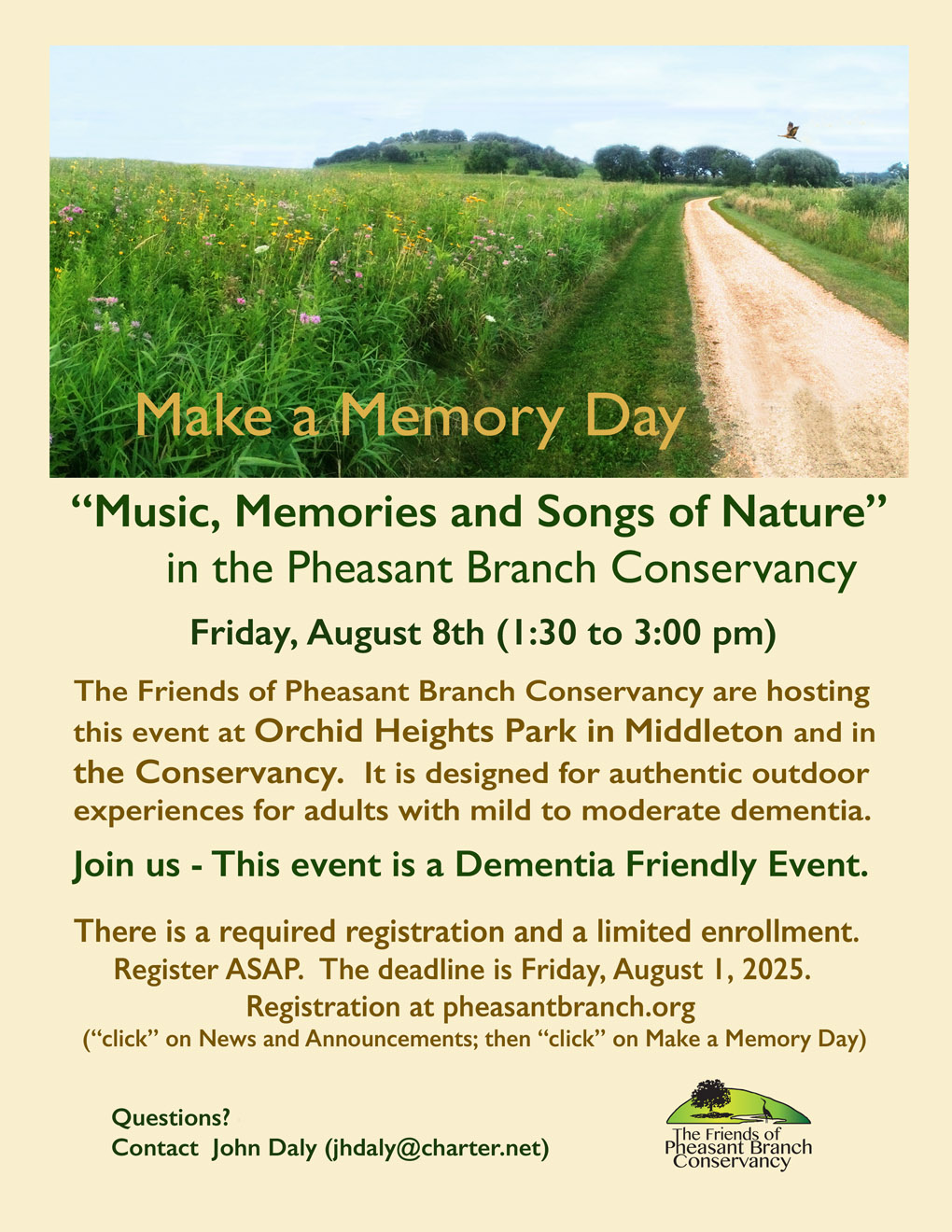
Join us for Make a Memory Day – August 8th, 2025 This is a Dementia Friendly FREE Event at Orchid Heights Park in Middleton and the Pheasant Branch Conservancy. Registration is required- REGISTER HERE Questions? Contact John Daly (jhdaly@charter.net)