
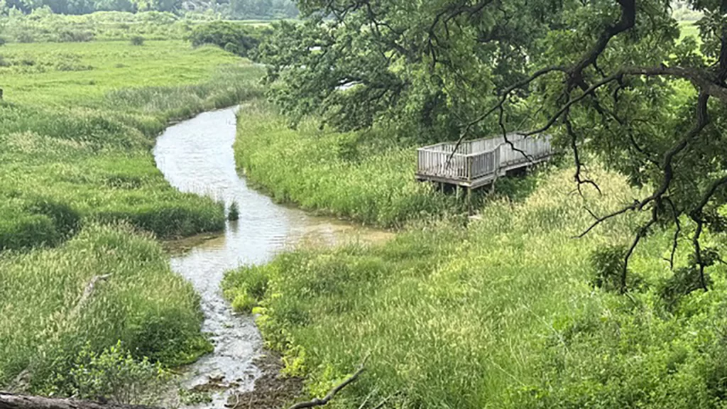
Hello, we are the commonly-called Pheasant Branch Springs, now known as the Frederick Springs after the farm family that sold this land to become a conservancy in modern times. We have existed here for many thousands of years, buried under the darkness of ice during the last glacial period. During melting and retreat of the glacier 18,000 years ago, glacial Lake Yahara (and also smaller Lake Middleton) formed behind the glacial fronts, backing water over the present four lakes by about 15 feet above current levels, covering the marsh and these springs as a bay of Lake Yahara.
Lake Yahara lasted for several thousand years, slowly draining as sediment deposits eroded downstream, and by 11,000 years ago declined to about present-day water levels, creating bogs, peat deposits and clay in these flats; as waters drained, they formed these wetlands and attracted early native people during seasonal migrations.
The springs and the marsh haven’t always looked the way they do today. Ancient Lake Mendota 8,000 to 3,000 years ago was much lower than present-day levels (by about 15-20 feet) exposing the springs and wetlands. Native people gathered and worshiped at these springs and other numerous springs in this area during their seasonal migrations, attracted by the water, wildlife, food, and other abundant resources. They believed that springs were sacred and a passage to the mysterious underground, possessing spiritual qualities. About 2,000 to 3,000 years ago, Woodland people lived here and built conical and linear burial mounds near the springs, wetlands, and lakes. Between 700 A.D. and 1605 A.D., Woodland and Mississippian societies (including ancestors of the Ho-Chunk) constructed many groups of effigy mounds throughout southern Wisconsin.
When European settlers arrived, Lake Mendota water level was also lower than today; early settlers built a mill dam at the outlet of Mendota in the 1840s, raising the lake level about 5 feet, flooding this wetland and creating a marsh with more open water. This condition was made permanent with the construction of the Tenney Park locks and dam in 1896. Water over the springs and marsh is regulated by the Lake Mendota water level. From early history to the present day, the springs known as Frederick Springs have served as a source of clear and cold water for fish, wildlife, and vegetation of the marsh.
We are the fourth largest natural spring complex remaining in Dane County. A second smaller (but also significant) spring complex exists in the small drainageway just west of the Homestead site. Following are some interesting facts for humans about the springs.
The recharge area supplying the springs extends to the northwest along the watershed boundary highlands beyond Ashton (Figure 2). There are three main sources of ground water to the springs:
1. Shallow sand and gravel glacial deposits-thickness variable
2. Upper bedrock dolomite and sandstone- about 300 feet thick
3. Lower bedrock aquifer (Mt. Simon sandstone)-about 500 feet thick
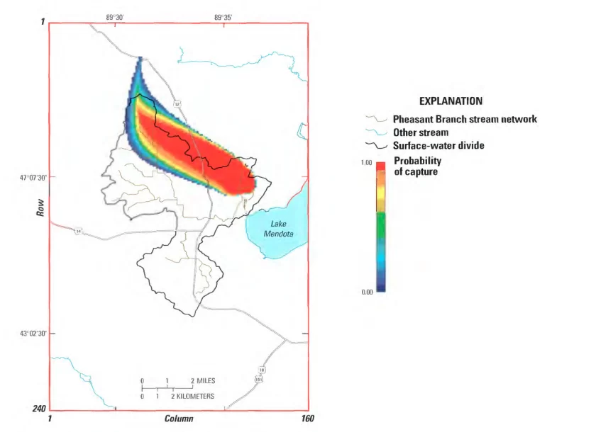
Figure 2. Simulated recharge area in the lower bedrock layer for Pheasant Branch Springs, Dane County, Wis. (from Hunt and Steuer, 2000)
Aquifers (Figure 3) are separated by a shale (Eau Claire shale) confining layer about 20 feet thick (missing here near Lake Mendota, where it was eroded away, and allowing ground water under artesian pressure to flow vertically through bedrock fractures to reach the surface).
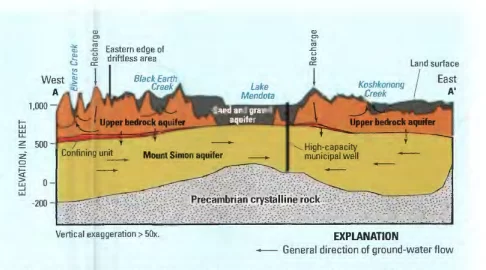
Figure 3. West-to-east cross-section showing the upper aquifers in relation to the lower (Mt. Simon) aquifer. (from Hunt, Bradbury and Krohelski, 2001, USGS Fact Sheet FS127-01)
The flow of Frederick Spring varies from 2-3 cubic feet/second (cfs), depending on dry or wet years. Flows have been monitored by the Friends since 2001. During those years, the average long-term Frederick Springs flow is 2.5 cfs, equivalent to 1,120 gallons per minute. The combined flow of both springs equals 3.9 cfs, or 1,780 gallons per minute.
The total flow from both springs for just 1 DAY is enough to supply water for about 30 households for an entire year, or cover one acre of land with water 7.7 feet deep!
The water temperature discharged by the springs from deep below ground is a consistent 50 degrees Fahrenheit year-round—warm in winter providing ice-free open water downstream into the marsh, and cold clear water in summer. The flow from the springs is important as it provides a consistent supply of clear, sediment-free and low-nutrient water to the marsh and Lake Mendota, more than two times the low flow (1.6 cfs) of Pheasant Branch Creek.
Springs are also affected by modern human activities. Springs are a declining resource threatened by well pumping for municipal uses and by urban development—impervious surfaces reducing infiltration and recharge of aquifers. Many springs have dried up or have decreased flows surrounding the Madison lakes area, such as near Spring Harbor and Nine Springs in Madison, and the Middleton Springs area.
The Friends of Pheasant Branch Conservancy and County Parks staff have worked hard over 30 years to protect our soils and water, clear invasive plants, and plant native species to keep our waters clean and wildlife habitat healthy, protecting and maintaining the springs undiminished for future generations. A new boardwalk and platform were recently installed (Figure 4) to provide improved access to view and dip your hands into the cold, bubbling water up close, and help protect the sensitive organic soils and vegetation from being trampled.
Please help us by enjoying these sacred springs from the safety of the platform. It is a place to sit, reflect, listen to the springs and marsh, and open your heart to the wonder and spirituality of the springs, as the Ho-Chunk ancestors did.
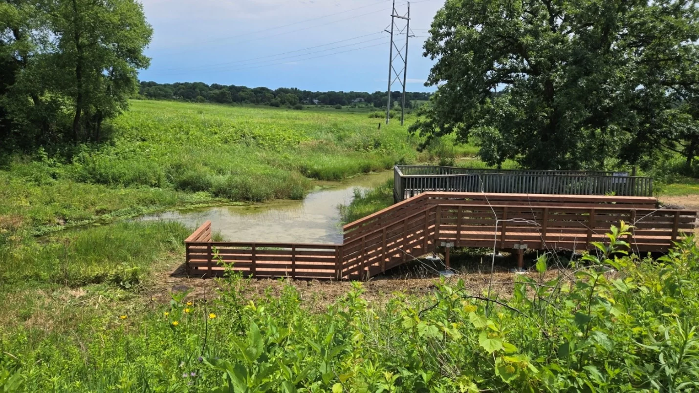
Figure 4. New boardwalk and platform installed at Frederick Springs, July 2026.
Glacial history according to D.M. Mickelson, WGNHS, 2007.
Related Articles
Seed the Need: Planting a Platinum Prairie on the New 160-Acre Parcel
Learn about the Friends’ plans to plant a Platinum Prairie on a newly acquired parcel of land that has been added to the Conservancy.
Learn More →
Redtail Ridge Development Leads to Pheasant Branch Conservancy
Redtail Ridge runoff threatens Pheasant Branch Conservancy. Discover why sustainable practices and resident action are vital to protect the watershed.
Learn More →
The Effects of Salt Use in Winter
Salt can have a detrimental effect on local waterways. What does that mean for Pheasant Branch Creek?
Learn More →